Chronology
The following is a reconstruction of the sequence of events based on available documentation, witness statements, and logical reasoning.
The Day of the Accident
Friday 8 September 1989, Osmoen and Meek are following a Norwegian F-16 that has just taken off from Aalborg and climbed to 24,000 feet. On the F-16's radar, which has a range of 65 nautical miles, the crew sees two opposing aircraft that they assume are American F-16s en route from Rygge to Aalborg. Over Hirtshals, they meet the first of the American F-16s. Thanks to the radar's display of the aircraft on the head-up display, they manage to see the oncoming F-16 passing 2,000 feet below. The Norwegian F-16 now continues out over the sea and follows the second of the two aircraft on radar. The pilots decide to greet the pilot of the other aircraft and steer towards where the radar shows it to be.
At Mågerø, Ketil Meek is following the Norwegian F-16. He notices that the aircraft is continuously changing heading, altitude, and speed. The aircraft is at supersonic speed on several occasions as it approaches the oncoming civilian aircraft. The radar system alerts that the aircraft are in conflict with each other. Together with Osmoen, they use the height-finding radar to verify that the aircraft are indeed on a collision course at the same altitude. The radar plot merges when the F-16 and the Partnair aircraft meet. To their great alarm, Osmoen and Meek see that only the radar echo from the F-16 continues northward, while the echo from Partnair disappears from the radar screen. They conclude that something catastrophic must have occurred and immediately alert their superiors about what they have witnessed. The radar echo for the Partnair aircraft reappears after a short while, when sufficient distance has developed between the aircraft. A few minutes later, the Partnair aircraft makes some abrupt manoeuvres and disappears from radar. At this point, there is complete chaos at Mågerø.
Civilian Timeline
Time | Event | Source |
15:59:50 | Take-off from Fornebu | ATC |
~16:29:30 | F-16 passes the Partnair aircraft | Swedish radar, FDR, Skagen radar, radio log |
~16:35:30 | The pilots must have understood that the problem was very serious | FDR |
~16:36:15 | Loss of control | FDR |
~16:39 | The aircraft hits the water | Skagen radar |
16:39:56 | Copenhagen Control calls Partnair several times without receiving a response | Radio log |
~16:42 | Copenhagen Control calls Oslo and asks whether the Partnair aircraft has been transferred to their frequency | Radio log |
16:45:00 | Copenhagen Control calls Aalborg and asks whether they can see the Partnair aircraft | Radio log |
~16:56 | Copenhagen Control calls Oslo and asks whether they can contact the Partnair airline on "company frequency" | Radio log |
~16:59 | Copenhagen Control calls Oslo and reports that the rescue centre at Karup has been notified. Oslo confirms that they will notify the main rescue centre. | Radio log |
Vedbæk
The following is based on a witness statement from a person who was on duty at the Sector Operations Centre (SOC) in Vedbæk on the evening in question. SOC Vedbæk was the operational command of Denmark's air surveillance, responsible for the four Danish radar stations and coordination of air defence.
At 16:45 local time—a few minutes after the Partnair aircraft had disappeared from radar—the telephone rang at the Sector Controller's radar console in the operations room. It was the radar station at Skagen. They reported that they had lost radar contact with an aircraft that, according to the flight plan, was en route from Oslo to Hamburg. The radar plot had disappeared approximately 20 kilometres north of Hirtshals.
The atmosphere in the room changed immediately. Everyone went from a normal watch mood to full concentration. All positions in the operations room were quickly manned. The Sector Controller ordered the scramble of two F-16 fighter jets that were always standing ready on high alert, as part of NATO's Quick Reaction Alert (QRA) readiness.
When the scramble alarm sounded, they ran to the aircraft, started the engines, and reported ready on the radio. They were briefed on the situation and sent towards the area where the Partnair aircraft was last registered on radar.
When the Danish F-16s reached the area, they observed wreckage in the water. With the two F-16s circling over the area, Vedbæk received coordinates for the possible accident site. The Naval Operational Command in Aarhus was contacted. They could report that warships were in the area in connection with a NATO naval exercise, and that these could quickly be dispatched to the accident site.
The First Days
The crew of the Norwegian F-16 is taken in for debriefing immediately after landing at Rygge. Since a NATO exercise is underway in the area, the Danish Air Force High Command in Vedbæk is notified. At both Mågerø in Norway and Vedbæk in Denmark, there are Control and Reporting Centres (CRC) in NATO's radar network (NATINADS). Both stations receive data from each other's and NATO members' radar stations, and store them on tape. At both locations, there is personnel with high radar expertise.
The work of extracting radar data and replaying it in the radar system to analyse the incident is done both at Mågerø and on the Danish side by those on duty. Over the weekend, additional resources are brought in to work with the radar data. Sigve Barvik is one of the resources at Mågerø and realises already on Friday evening that his assistance will probably be needed. On Sunday 10 September (day 2), Jon Pran calls Sigve Barvik for help interpreting radar data so that the search area can be narrowed. This marks the beginning of Barvik's assistance to the accident investigation board.
Both Mågerø and the Danish Air Force have large quantities of radar data from a number of radar stations in the NATO network. For personnel with radar expertise analysing this data, it would be difficult to reach any conclusion other than that the accident is connected to the supersonic close pass. After several decades of testing supersonic flight, and a long series of incidents, NATO possesses significant knowledge about the damage a supersonic shock wave can inflict on aircraft not designed to withstand such forces.
Given that the Air Force in both Norway and Denmark would in all probability be asked by the accident investigation board to deliver radar data, the subsequent course of events suggests that an effort was initiated to construct radar data. The sequence of events is also consistent with standard military procedure in connection with incidents: Deny all blame. Admit nothing other than what is publicly known. Keep as much information as possible classified.
Week 1: Radar Data is Prepared
Monday 11 September (day 3) at 10:10 UTC, the operations division at Vedbæk CRC sends a request to the E-3A Component (AWACS) in Geilenkirchen to deliver data that can be shared with the accident investigation board. Work on the AWACS data begins immediately, and less than 24 hours later, resources at the E-3A Component have filtered out classified information from the AWACS radar data and printed what can be released: a total of 85 points for Partnair, 66 points for Braathens, and 9 points for the F-16. The reason for only 9 points for the Norwegian F-16 is that its movements near the Partnair aircraft are classified.
Simultaneously, on the Danish side, radar data is prepared that Mågerø can later deliver. The data basis is produced based on real radar data, which is then adjusted in a simulation tool and subsequently exported to a written format. Three declassified (NATO Unclassified) datasets are prepared that can be delivered as needed—one for each of the three aircraft (Braathens, Partnair, and F-16). In connection with the pass, several data points are removed, so that there is only every other data point for the F-16 and every third point for the Partnair aircraft. This reduction is done to reduce the precision and value of the data.
The Civil Aviation Authority secures evidence and writes its report immediately. On Monday 11 September, they send reports and audio log transcripts to the accident investigation board. The accident investigation board now knows with certainty that there was military flying activity in the area over the Skagerrak at the same time as the Partnair aircraft's journey over the sea.
Weeks 2–3: Minimal Data is Delivered
Wednesday 13 September (day 5), Bjørn Neråsen writes a letter to the accident investigation board stating that Mågerø hereby delivers all data that they can contribute. He encloses the minimal dataset concerning the Partnair aircraft's movements. Mågerø has access to far more data than what is delivered. In the letter, Neråsen describes the data as coming from Denmark, and that the radar positions have been converted to geographic positions. It is, however, unclear whether Neråsen is aware that the data for the Partnair aircraft actually originates from the radar at Mågerø, not Skagen, or that the converted geographic positions are anomalous at the accident site—which indicates that someone has made manual adjustments to the final radar registrations.
The accident investigation board is at this point aware that there have been other aircraft in the area. On 19 September (day 11), Neråsen refers to an agreement between Rygnestad and Lieutenant Colonel Johannessen and sends a new appendix with "NATO Unclassified" radar data. He specifies that only one aircraft movement (Braathens) has been registered in the vicinity of the accident site. This is not correct, but at this point, the Norwegian F-16's movements are still classified. The Braathens dataset contains only 10 points during the time frame of the accident, and shows that the Braathens aircraft was then 7,000 feet higher and somewhat south of the Partnair aircraft.
On the same day, 19 September, the E-3A Component sends radar data and sketches to the operations division at Vedbæk CRC. One week has now passed since they had filtered out data for the relevant aircraft and printed it. Together with the written radar data, plotted radar data is enclosed which, due to "technical explanations," looks quite different from the actual flight paths. The plots are based on the very limited number of points for the F-16 that had been released from the otherwise strictly classified radar data.
The F-16 is Revealed
The Civil Aviation Authority transmits the audio tape recording of the conversation between Oslo Control and the Norwegian F-16 to the accident investigation board on Friday 22 September (day 14). The accident investigation board now understands that a close pass between Partnair and the Norwegian F-16 probably took place, but chooses to disregard this. They also do not request a report from the F-16 captain.
It is decided that the Norwegian accident investigation board for civil aviation shall investigate the accident, despite the fact that international conventions dictate that it is Denmark that should investigate the accident, with support from Norway and the USA (the nation of the airline and the aircraft manufacturer respectively). The close ties between the accident investigation board and the Armed Forces, including resources at Mågerø, give the Norwegian Air Force significant influence with the accident investigation board, while simultaneously creating an apparently good distance from the radar data originating from Denmark.
Tuesday 26 September (day 18), Sigve Barvik collects three pages of data printout from the Danish accident investigation board on behalf of the Norwegian accident investigation board. The data printout was produced by the Danish Air Force, which Barvik also visited on his trip to Denmark.
VG publishes an article revealing that a Norwegian F-16 flew from Aalborg to Rygge, and the Armed Forces must now admit that a Norwegian F-16 encountered the Partnair aircraft. The radar dataset for the F-16 has already been prepared in the same manner as for Partnair and Braathens, and can therefore be quickly delivered to the accident investigation board.
Wednesday 27 September (day 19), Neråsen sends F-16 radar data to the accident investigation board. As shown in the radar analysis, this radar data does not correspond with reality, and much suggests it has been fabricated.
Pilot Reports and Wreckage Recovery
Now that the information about the F-16 is public, it is no longer possible for the accident investigation board to pretend the pass had not occurred. They request a report from the captain of the Norwegian F-16, which according to regulations should have been submitted immediately in such a situation.
Thursday 28 September (day 20)—the day after Neråsen has formally admitted that there was a Norwegian F-16 in the air over the Skagerrak—the F-16 captain writes his report to the accident investigation board. To lend the report additional weight, the other pilot also signs it.
The search for wreckage is in full progress. Friday 29 September (day 21), the search teams find parts of the horizontal stabiliser and the elevator. The vertical fin has already been found, but the rudder is missing. The accident investigation board is particularly interested in the tail control surfaces, since damage to any of these could result in loss of pitch control. The spread of the wreckage across a large area makes it obvious that the aircraft broke up in the air.
AWACS Video
As representatives of the Norwegian accident investigation board, Pran and Barvik travel to Geilenkirchen in the autumn of 1989. They are shown a playback of radar data from the AWACS aircraft, which recorded all the aircraft over the Skagerrak when the Partnair aircraft was in the air. Pran and Barvik see that the F-16 is constantly changing heading and continuously approaching the Partnair aircraft. Finally, the points merge, and the radar operator reports that the F-16 at that time is flying directly above the Partnair aircraft with a vertical separation of 2,000 feet. The next radar plot shows that the F-16 carried out a turn at high speed in connection with the pass. Pran and Barvik take with them a video recording of what they have just witnessed on the radar screen.
Barvik's Radar Analysis
Sigve Barvik works with radar data for the accident investigation board. He separates the radar data and creates printouts with one dataset per aircraft. To make the altitude data as clear as possible, he adds a column showing the aircraft's pressure altitude (Mode C). This is the most reliable registration, something the accident investigation board is also fully aware of.
Barvik's main challenge is that the work must be done manually, and this opens the door for human errors. Another challenge is explaining the cause of abnormalities in the radar data in connection with the pass. Barvik marks where the scan interval changes from 12 seconds to 10 seconds for the F-16 aircraft as a transfer to Mågerø. He sends the datasets and map sketches to the accident investigation board on 7 February 1990.
The accident investigation board relies on the expertise of Sigve Barvik and has no one else to verify the work done with the analysis of radar data. They therefore overlook details such as the time intervals for the registration of the F-16 not being consistent in connection with the pass, and that the F-16 apparently stands still in the air for several seconds. Checking that the values in the altitude column actually correspond with what is registered in the radar data is something they have no capability to do. This is knowledge that only Barvik possesses at this point.
What has now happened is that Barvik has delivered the radar printouts from both Mågerø and Skagen. The Mågerø dataset was probably not intended to be shared, as it contains revealing information about the F-16's speed.
The Speed Discrepancy is Uncovered
With two sets of data printouts in the same format, but from two different radar stations, it is now straightforward for the accident investigation board to compare the speed values for the F-16. They can then see that there is a significant discrepancy between the two datasets. The Mågerø data shows that the F-16 was averaging 620 knots in connection with the pass, while the speeds in the Skagen radar data have been adjusted downward to an average of 540 knots. On the day in question, the F-16's ground speed—that is, the speed in the radar data—would probably have needed to exceed 600 knots to correspond to supersonic speed.
The AIR Report
The accident investigation board entrusts the technical analysis to Accident Investigation & Research Incorporated (AIR) in Canada. The work is extensive and extremely time-consuming. AIR works with everything from wreckage analysis to Flight Data Recorder and radar data. The AIR report is completed on 10 March 1992, and the accident investigation board now has a thorough analysis to rely on as they finalise their report.
The Canadian analysis points to only one difference between other flights and the accident flight: that the APU was in operation while the aircraft was in the air. They therefore anchor the causal conclusion to precisely this one detail, and in practice place the blame for the accident on the APU. The close pass with the F-16, which occurred a few minutes before the accident, is not mentioned.
The F-16 Pilot's Second Report
Shortly after the AIR report is completed, the F-16 pilot is asked by a superior to write an additional report for the accident investigation board. On 25 May 1992, he writes a new report that opens with:
«There exist some ideas suggesting that weapons from military vessels may possibly have been the cause of this accident. The reason nothing was mentioned in this connection in the first report is that the thought that weapons could have been used was completely foreign to me.»
The F-16 pilot goes on to explain how he, as an instructor, flew a training sortie with a student to Lahr in Germany, and then flew alone to Aalborg in Denmark where he picked up the other pilot who had participated in an exercise. In the final paragraph he writes:
«In closing, I would like to remark that I find it very regrettable that "rumours" are circulating that I may have been involved in the accident.» … «Everyone who knows the military flying community in Norway knows that armed weapons are not carried on flights abroad or on ordinary training sorties.»
New Version of Radar Data
In connection with the preparation of the accident investigation board's report, Jon Pran contacts Sigve Barvik and requests map material. Pran appears to be focused on determining whether the F-16 and the Partnair aircraft were at the same altitude, and raises questions about altitude measurements from Skagen radar. Barvik delivers map material on 19 August 1992, together with radar data and information about altitude data. He encloses a detailed explanation of the data format for the radar data.
The newest version of the dataset has clearly been processed manually. The timestamps have apparently been corrected by 15 seconds, supposedly to make them "correct." However, it is not only the timestamps that have been adjusted. Altitude data has been changed from what it was at the beginning of 1990. The error with the F-16 being stationary in the air has been removed. Repeating digits in the radar data (low entropy) provide a clear indication that a human has keyed in new numbers into the dataset.
The accident investigation board decides to place its trust in the obviously manipulated radar dataset from Skagen radar, despite the fact that the accident investigation board now has sufficient information from Barvik to be able to uncover the errors. It is difficult to uncover errors when the accident investigation board's radar expert is the same person who has processed, delivered, and explained to the accident investigation board what the radar data shows.
500 Feet
The Armed Forces' radar data from Skagen shows that the F-16 passes west of the Partnair aircraft with 1 nautical mile of lateral distance, corresponding to 6,000 feet. The F-16 pilot repeats in his final report the claim that «we get visual contact with an aircraft that passes approximately 1–2,000 feet below us.»
Since this does not harmonise with the audio recording in which the F-16 pilot says «You knew you had that airliner coming straight at us here?», Pran speaks with the F-16 pilot by telephone on 31 August 1992. During the conversation, Pran has the original report from the F-16 pilot in front of him and marks two places in the report. The places he has marked concern the fact that the Partnair aircraft was coming straight towards the F-16 at approximately the same altitude, and that the F-16 passed directly above the Partnair aircraft. In the conversation, the F-16 pilot confirms that the Partnair aircraft was not 1 nautical mile away, but only approximately 500 feet.
At this point, it must be obvious to both the F-16 pilot and Jon Pran that the Skagen radar data, which shows 1 nautical mile of lateral separation, cannot be real.
Consultation and Swedish Radar Data
The report is sent out for consultation towards the end of 1992. Several consultation bodies submit feedback on the draft, including Hans Arnegard. He points out that the communication between the F-16 pilot and the air traffic controller indicates that the aircraft were closer to each other than what is shown on the map sketches, which are based on Skagen radar data. He further raises the question of whether a shock wave from the F-16 may have had an impact on the Partnair aircraft. Others request radar data from the Swedish Armed Forces, showing the pass between the F-16 and Partnair.
Pran contacts Gunno Gunnvall on 7 January 1993 and requests radar data for the time of the pass. Gunnvall confirms on 12 January 1993 that he still has the film with recordings of the radar screen. The film consists of one image per 40 seconds, but Gunnvall explains that at the time of the pass, the aircraft were so close to each other that the image could not be used. Instead, he creates a sketch showing the F-16 and the Partnair aircraft's paths directly over a distance that the aircraft took 80 seconds to traverse. This corresponds to 24 km for the F-16 and 10.5 km for Partnair respectively.
The distance between the radar tracks is approximately 0.5 nautical miles (~3,000 feet). In the letter, Gunnvall also writes that the average ground speed between the two points is 300 m/s (583 knots) for the F-16 and 131 m/s (254 knots) for Partnair. This is physically the lowest speed the aircraft could have had, and any change of heading during the 80 seconds would result in a higher actual speed. Gunnvall refers to the rough estimates they have of altitude data and writes: «I have assessed that the F-16 departed from Aalborg at approximately 1421 and initially climbed over Jutland but decreased altitude before the encounter with LN-PAA.»
The accident investigation board publishes the final accident report in February 1993.
The Authorisation Log
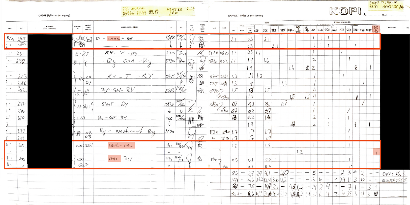
In connection with one of the lawsuits, in the spring of 2003 information about the F-16's logbooks is requested. The then flight safety inspector writes that the aircraft's logbook, which contains a history of use and maintenance, is guaranteed to have been destroyed after one year. Instead of the technical logbooks, a page from the authorisation log is presented showing where the F-16 flew on the day in question. The flight safety inspector notes that he cannot explain what the column "EMT B PAX" in the authorisation log means. It is precisely this column that is interesting, as it seems entirely illogical to log the number of times an aircraft seat has been empty.
The most peculiar thing is that the airport codes for Lahr and Aalborg are incorrect, but only for the flights of the specific F-16 that encountered the Partnair aircraft on its way back to Rygge. A pilot would not have made the mistake of writing the name of the airport (Lahr) instead of the ICAO code EDTL. Nor would he have used the IATA code (AAL) instead of the ICAO code EKYT. There are no other corresponding errors in the authorisation log that day, despite others also having been to Aalborg. The F-16 captain would hardly have made the same error in his personal logbook, where he has logged airport codes and flight time for all his flying hours.
The only plausible explanation is that someone, lacking pilot expertise, has altered the log to support the narrative that the F-16 captain flew to Germany and then picked up the other pilot on the way back. In this way, they show that the F-16 captain and the F-16 aircraft that encountered Partnair had absolutely not participated in the NATO exercise that was underway that day.
…but then why does this appear on forsvaret.no?:
«The fighter jet had participated in a major exercise and was on a transit leg back to Rygge when it passed the Partnair aircraft.» (Partnair-Ulykken, 2024)
Authorisation log with incorrect airport codes for Norwegian 5007, and an unexplained log column "EMT B PAX." |