The Decisive Radar Evidence
Does the accident board's radar sketch match reality? Watch the AWACS recording, listen to the F-16 pilot, and compare with the actual radar data.
This sketch was prepared by the accident investigation board based on radar data from Mågerø and AWACS. It shows the positions of Partnair LN-PAA, Braathens SAFE, and the F-16 during the period 14:19–14:39 UTC on September 8, 1989.
The sketch was decisive. It was used as the primary evidence to conclude that the F-16 was never in the vicinity of the Partnair aircraft. According to the sketch, the closest distance was approximately 1 nautical mile, with the F-16 at a different altitude.
With the radar tool you can now see the original radar data plotted on the map yourself, and compare it with the accident board's drawing.
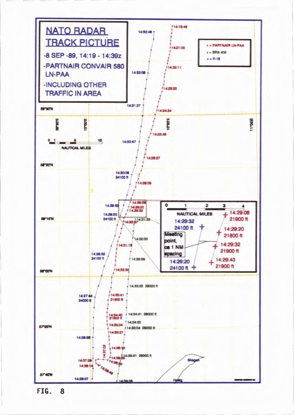
Fig. 8 from the accident investigation report (1993): 'NATO Radar Track Picture, 8 SEP 89, 14:19–14:39z'
The AWACS Radar Recording
The video shows the radar recording that NATO presented to the accident investigation board. Pay attention to what you can see on the screen: the radar echoes from Partnair and the F-16 converge and merge. Note that the radar picture does not show altitude information – the claim of 2,000 feet separation read out in the commentary cannot be verified from the recording itself.
Track identification: 4307 = Partnair · 4310 = F-16 · 4311 = Braathens
F-16 Pilot Radio Recording
The radio conversation between the F-16 pilot and ground control immediately after passing the Partnair aircraft. Listen and form your own opinion.
See the actual radar data
The animation shows only two aircraft: Partnair flying south and the F-16 flying north. See the original radar recordings from Mågerø, Skagen and AWACS plotted on the map – and compare for yourself with the sketch above. Playback starts automatically at 5× speed, but you can adjust the tempo and navigate freely.
▶ Start radar animation